
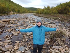
Mikel Calle Navarro, PhD
TSCMT Post-doctoral researcher at the Department of Geography
In 2022 I received funding from the TCSMT to perform a fieldwork campaign in the northernmost part of Finnish and Norwegian Lapland, the Tana River watershed1 (or Tenojoki in Finnish). This river works as a natural border between Finland and Norway for more than 150 km and its waters flow northeast to finally end up in the Arctic Ocean (Figure 1).
The goal of the field trip: to validate the river diversity model that we created in the computer. This basically means to compare whether the model is providing accurate prediction of the real diversity of river landscapes. Why? The idea behind is that the greater number of different river landscapes, the more biodiversity they potentially support. Besides, quantification of river ecosystems diversity, FLUVIODIVERSITY, also help us to estimate the capacity of each river type to resist the climatic changes that we are observing in the Arctic Region. But this needs an intensive monitoring of the river changes at multiple scales and combining computer models and fieldwork campaigns like this one.
Thus, in late August, after planning the potential study sites, I packed my gear and I hit the road to the north. I decided to start from the headwaters2. After crossing the border to Norway in direction to Kautokeino, I was almost ready to start the fieldwork campaign. The Figure 1 shows the route I followed to cover the most part of the river watershed. Since this area is quite big, I had to dedicate more than two weeks to reach all the selected points. Some days were long and especially tough when the rain was intermittently stopping the work. Nevertheless, I could visit some very astonishing and diverse river environments that made me evolve my current research and also my next project that I want to carry out in the area. Follow me in this campaign to discover more scientific aspects of these amazing river landscapes!
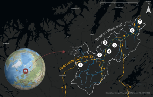
Figure 1: Route followed for the field campaign in late summer 2022.
1. HEADWATERS (Norway)
The first stop, the Norwegian high plains. In this area the road goes parallel to the river and crosses it many times. The calm waters flow intercepting meadows and lakes with very sporadic rapids. The river is here composed mostly by big sediment particles, around 20 to 30 cm in diameter. The river cuts the remnants from the past glacial activity, very smooth hills elongated towards the north, the direction of the ice (from right to left in Figure 2)
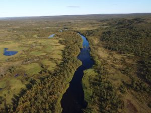
Figure 2: Point 1, Vuottašjohka, 333 meters above sea level (google maps coordinates 69.381416, 24.086965)
2. KARASJOK (Norway)
Following the Karasjok river to Karigasniemi, we observe a wide valley where the Karasjohka waters shaped a meandering pattern. The beautiful consecutive semi-circular bends (from the middle of the picture to the upper right corner) are built on sandy banks and slightly coarser river bottom. The meanders bends are so large (almost 1km radius) that are better seen on a map (click the coordinates to locate this point). The spring flood totally covers the exposed sediments of the picture and may even spill over the areas partly occupied by houses and fields. Some measures, such as erosion protection rock piles, can be found in these meanders.
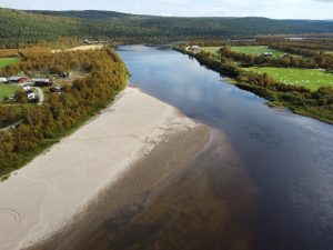
Figure 3: Point 2, Kárášjohka, 124 m.a.s.l. (69.451439, 25.591707)
3. MIDDLE TENO
It was a very windy day. The strength of the wind was so that it created an effect on the water that looked like it was flowing upwards (in the picture the water flows from down to up). In this area, the river enters a valley carved by glacial action, with steeper slopes but rounded tops, the fjelds. In this section, the river follows almost an orthogonal pattern, the river turns between 120 and 90 degrees. This can be seen in Figure 4 where the river is following a straight line then it turns to the right. This is caused by the intersection of rock fractures in the area. In this case the fracture, that the river is following first, continues to the valley in front. But the river turns into another one that follows a parallel direction to the hill tops to the right. The geology of the area, is another important factor to determine the present river diversity.
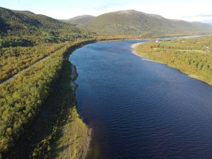
Figure 4: Point 3, Tenojoki, 106 m.a.s.l. (69.808762, 26.241613)
4. DÁLVADAS (Finland-Norway)
In front of Dálvadas town, the valley suddenly narrows confined by two lateral tributaries coming from Norwegian and Finnish sides. Right after, the valley expands forming this estrange form made of gravel size sediment. On top of it, one can notice striations caused by ice blocks drag by the river during the spring flood. During this period the water covers the bare sediment surface of Figure 5 and sometimes even some areas of the cultivated island in the centre.
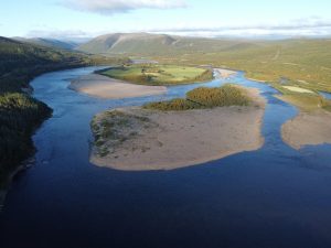
Figure 5: Point 4, Tenojoki, 108 m.a.s.l. (69.768441, 26.185502)
5. TRIBUTARIES OF THE MIDDLE TENO
Calm, crystal-clear waters in summer but powerful in spring. You can feel the power of the Spring flood on the sides and river banks, where broken trees and bushes shows evidence of the energy of the water and the hits of the ice blocks once the river ice cover breaks. The sediment size is large, from cobbles to boulders, showing also the high energy of the water that move them. These trybutaries are characterized by steep slopes. Many of these tributaries are spawning locations for salmon.
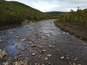
Figure 6: Point 5, Nilijoki, 132 m.a.s.l. (69.759611, 26.215561)
6. ALAKÖNGÄS (Finland-Norway)
From Dálvadas to Polmak the river valley can be almost considered as a gorge. But before reaching Nuorgam town, we find the narrowest section of all, Alaköngäs. It is also the steepest part of the main channel. It drops 10 meters in just 1.5 km. Imagine the water forced to flow through this narrow, with floating ice blocks and moving rocks. Must be quite impressive… Also interesting is the origin of this narrowing. It is caused by the sediments deposited by the river thousands of years ago (on the right side in Figure 7), little after the glacial retreat. The effects of past glacial interactions with the landscape also influences the present river forms and diversity.
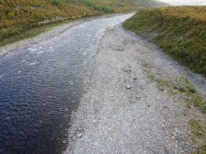
Figure 7: Point 6, Tenojoki, 24 m.a.s.l. (70.077061, 27.682774)
7. LOWER TENO (Norway)
From Polmak to Tana Bru the valley starts to expand giving more space for the channel to form lateral sediment deposits (river bars). Tana Bru is the last narrow section of the river, constrained by the presence of thick accumulation of glacio-fluvial deposits, similar to the Alaköngäs case. From there toward downstream we observe a fjord-like valley completely filled with sediments (Figure 8). During the Spring snow melt the water covers 1.5 km in width. In the very end of the Tana River, the waters meet the Sea forming a delta, which is a natural reserve. This shows the large volume of sediments that this river has transported, and still transports today, towards the Arctic Ocean. Rivers draining to the Artic are the ones in charge to supply nutrients, carbon, and heat that control the biological productivity of the organisms living in it. We expect that changes in the rivers will not only affect the rivers itself but also the Arctic marine ecosystem.
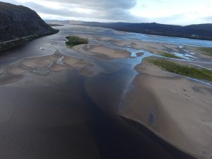
Figure 8: Point 7, Tana River, 1.3 m.a.s.l. (70.436161, 28.311481)
This was the end of my trip from a scientific point of view. It was time to drive south, process the data and prepare for the winter to come, with renewed confidence in the importance of our understanding of the impacts of Climate Change in these remote but sensitive ecosystems.
-
The catchment or watershed is the area draining towards the same point, in this case to the Barents Sea.
-
This term is used to indicate the uppermost part of the river, the area where a river is born.