Field station full of stories

Month: October 2017

Surveying meadows in Seili

Meadows are traditional biotopes in Finland and during this summer we took a closer look at meadow plants in Seili. Proper equipment and careful planning are the basis of sampling plants. It’s wise to keep close to you at least a good plant identification guide and a sampling square (quadrat). Sometimes a magnifying glass is also necessary to check some small details.

Cover and density estimates are important parameters of changes in vegetation. This inventory also gave an opportunity to pause and admire the beauty of the plants, butterflies and other insects.

A quadrat is a plot used in ecology to isolate a standard unit of area for study of the distribution of an item over a large area

Common Moonwort (Botrychium lunaria)

Field Cow-wheat (Melampyrum arvense)

Text and photos: Jasmin Inkinen, Archipelago Research Institute’s preparator

This is a short version of the original Finnish blog post, see the original post here.

See also: Natural environments in Seili (part 1)

Keep calm and keep monitoring – on the importance of environmental monitoring

Last week, the mainstream media in Finland and abroad (e.g., here and here) reported of a research, published in the journal Plos One, where three-quarters of flying insects in nature reserves across Germany were observed to have vanished in 27 years. The results are alarming as insects are an integral part of life on Earth as both pollinators and prey for other wildlife. Thus, the scale of the losses to all insects will have profound impacts on human society.

After reading the article, in addition to the consequences of these results, I started to think about long-term environmental monitoring and its significance. Monitoring programs are often criticized as “costing too much while delivering too little” and most funding is granted to short-term research projects. So, what is so important about environmental monitoring? How do we benefit from these long data sets?

Field course students  examining insect samples, collected in Seili. In the back of the photo is a Malaise-trap similar to the ones used in the German study. Photo from ARI’s archive.

Environmental monitoring can be described as a programme of recurring, systematic studies that reveals the state of the environment and separates anthropocentric effects from natural processes. Monitoring can be conducted for a number of purposes, for example to establish environmental baselines or identify trends. Environmental monitoring programs also vary significantly in the scale of their spatial and temporal boundaries, and scope. Ecosystems in general require long-term monitoring because they are complex and sensitive, and most key changes in the environment take place over prolonged periods.

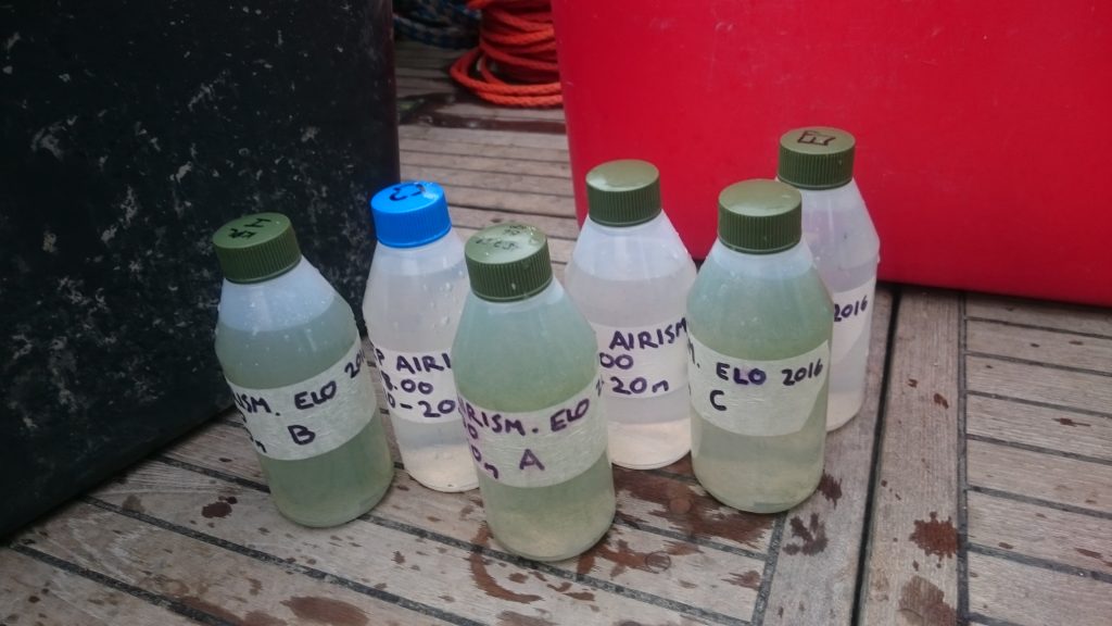
In zooplankton research, even a 20-year-long data set is sometimes not considered long enough to reveal underlying trends. Decades worth of data contain a lot of sample bottles. In the photo are some monitoring zooplankton samples, collected from the Airisto Inlet, Archipelago Sea. Photo from ARI’s archive.

The participation by amateur naturalists and other collaborators can be invaluable to the monitoring program because of  funding shortfalls and the large amount of work that goes into the collection and analysis of samples. For example, the data used in the German study, was largely collected and analyzed by amateur entomologists (Krefeld Entomological Society).

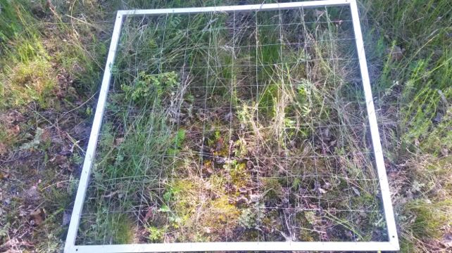
Environmental monitoring is a central part of many field station’s work. The location, infrastructure and trained staff make it possible to sample year round.  In Seili, the abundance of ticks have been monitored since 2012. The aim is to eventually have a long time series of tick abundances. Photo by Esko Keski-Oja.

The condition of the spawning herring population has been monitored in Seili for over 30 years and this cooperative effort has resulted in data sets that are unique in even in the Baltic Sea scale. Local fishermen have been an important part of this project as without their help, the collection of fish samples would have been difficult. Photo by Juha Kääriä.

What is good quality monitoring? For one, systematic sampling is key in order to get trustworthy and comparable results, and neglecting this step might make the whole data series completely useless. In the German study, this meant for example that the size, shape,color, location and placement of the trap had to be similar in each of the 63 sampling locations. Also, the way the insects were preserved, handled and analysed had to be the same. Thus, quality assurance certainly isn’t easy, and systematic work is required in each step of the way as more often than not, several people participate in the collection and handling of the time series.

Systematic sampling is key in environmental monitoring in order to get trustworthy and comparable results. In the photo, the species composition from a sample, collected with a light trap in Seili, is under analysis. Photo by Katja Mäkinen.

Monitoring programs are often criticized as “costing too much while delivering too little” and the lack of funding has often forced officials to curtail monitoring and data collection. However, environmental monitoring serves a vital scientific role by revealing long-term trends that can lead to new knowledge and understanding. For example, Charles David Keeling’s long-term measurements of atmospheric carbon dioxide at Mauna Loa island, Hawaii, provided the first unmistakable evidence that carbon dioxide emissions from human activities were warming the Earth (the famous Keeling’s Curve). As a result of this careful and consistent work, global climate change is now widely accepted as a scientific fact!

The results of monitoring are also of fundamental importance for evaluating environmental planning and policy as it is only through such careful observation that we can evaluate the health of our natural resources and make science-based management decisions. Also, the drafting and prioritization of environmental policies is based on the findings of environmental monitoring.

Cost-efficiency requires that monitoring programs  adapt new methods. Environmental monitoring is becoming increasingly automated. The ODAS buoy of Seili (in the photo) measures seawater parameters from a water column 4 times a day and sends the data automatically to the ARI’s administered Saaristomeri.utu.fi website. In 2015, also a weather station, measuring e.g. air temperature, wind speed and direction was added to the assembly. 

See also: The long tradition of environmental monitoring in Seili (an English translation at the end of the post)

Text: Katja Mäkinen, research technician and PhD researcher, working with long-term environmental data and monitoring.

Watching nature’s family drama unfold on live webcam

In the eastern side of the Seili island, on top of a leading mark, is a nesting  Osprey (Pandion haliaetus) couple totally unaware of its fame. The breeding of this second largest predatory bird species in Finland has been monitored through a web camera since 2006. The Osprey web camera was installed in Seili by the Turku University of Applied Sciences as part of NatureIT-projects and later, continued as part of Saaristomeri.info and BalticSeaNow projects. The last project, EU-funded BalticSeaNow ended in February 2013. Since 2015, the Archipelago Research Institute has participated in the maintenance and funding of the web camera and connections. The latest addition to the camera was a microphone, added to the camera assembly in 2016, so that sound can be transmitted. The Osprey cam can be found in the Saaristomeri.utu.fi website, updated and administered by the Archipelago Institute.

Like several other web cameras in Finland and worldwide, the Osprey cam of Seili has been very popular since its beginning. At its best, the ospreys have reached one million views per year! The camera is operated year round. During winter, viewers can admire the changing archipelago scenery and white-tailed eagles, crows, and ravens, occasionally visiting the nest.

At the moment, it is quiet, only the whistling sound of wind is heard through the speakers. The male osprey, called Vasuri (loose translation “lefty” or “left hand”), and the oldest two chicks, unofficially called Pomo (“the boss”) and Kakkonen (loose translation “the second” or “number two”), started the migration to Africa in August. The year has been a dramatic one for the osprey couple. The female osprey, called Tilda, disappeared from the nest in June. The couple had been nesting in Seili since 2011; before that, e.g. an osprey couple, called Tapani and Liisa, occupied the nest.

This spring, Tilda and Vasuri laid 3 eggs. The chicks were ringed in June. After the disappearance of Tilda, another dramatic event occurred in July, when the youngest sibling fell from the nest to its death as a result of food competition with the older siblings. This sort of behaviour, called siblicide, is rather common among birds and has been found to e.g. improve the survival of the remaining young (for more information on avian siblicide see e.g Mock et al. 1990).

Next spring, in March-April, when the ospreys return from their wintering grounds, nature’s drama continues and it remains to be seen whether Vasuri will return to the nest or will the nest be occupied by a totally new osprey couple..

References and more information:

Edit: corrected date.

Natural environments in Seili (part 1)

For those who enjoy the outdoors, the nature of Seili offers unique experiences. In this post series, you’ll find everything you need to know on exploring Seili island’s lesser-known natural wonders. In this first post, we’ll introduce the different natural environments of Seili. Later, we will focus for example on species restoration, habitat conservation, and endangered species found on the island.

Heritage landscape in the middle region of the island. View from the White house towards Lembergsviken. Photo: Tommi Pohjakallio.

The diversity of environments is a typical characteristic of the middle archipelago region. Distinct feature for Seili is traditional farming and settlements, which have left its traces in the landscape. The first fields in Seili were cleared in the Middle Ages and grazing animals have altered the surroundings. Due to mans clearing of forests into fields, meadows and grazing grounds, many plant species have also spread to new areas.

Professor Mikko Niemi’s sheep used to graze freely on the island in the 1990s. Photo: ARI’s archives.

Since 2013, cattle have been again grazing on Seili. The aim is to restore the landscape to its 19th-century state when the practice of grazing was more common. Photo: Tommi Pohjakallio.

After the closing of the hospital, the buildings, and land and sea-areas of Seili were divided between the University of Turku, the Finnish Forest Research Institute (Metla) and the Archaeological Commission. The state-owned forest areas were included in the Solböle research forest area and, consequently, several non-native tree species were planted in the open fields and meadows, some of which can still be found on Seili today. Metla administered the state-owned forests until 1995 after which the administration was put in the hands of Metsähallitus Parks and Wildlife Finland. Nowadays Seili is involved in a range of biodiversity protection programmes, including Natura 2000 and the Shore Conservation Programme. The buildings and historical artifacts and sites are also protected. For these reasons, open fire, camping, digging etc. are not permitted on-site. To prevent erosion, visitors are also requested to stay on existing roads and paths.

The current natural environment on the island can be divided into three parts: the lush and rich herb-rich forest in the south, the open heritage landscape in the center and the rugged north, dominated by coniferous trees. The rarest habitats on Seili are the large hazelnut bush herb-rich forests on the southern part and rocky grasslands in the center.

Lush hazelnut bush herb-rich forests are found at the southern end of the island. Photo: Katja Mäkinen.

The rugged landscape of the north. Most of the forest area here is classified as natural forests. Photo: Katja Mäkinen.

Walking towards Kirkkoniemi, the most notable land formation is a tombolo, a deposition formation. The tombolo ties together the main island of Seili and Kirkkoniemi, which used to be separate islands still in the mid- 19th century! Photo: Milla Aironsalmi.

Field cow-wheat (Melampyrum arvense), a vulnerable, protected species, grows rather abundantly on Seili. Earlier it was considered as a problematic field weed, but disappeared, apparently due to a change in farming methods.  Photo: Milla Aironsalmi.

Sharp-eyed visitors may spot some species, such as the vulnerable field cow-wheat (Melampyrum arvense), and soapwort (Saponaria officinalis) and Burnet rose (Rosa spinosissima), favoured by traditional farming practices and/or other human activities, in the center and next to the main building. In the future, visitors may familiarize themselves better with these plants, as we are planning to restore an old park and garden of useful plants, which existed next to the main building in the 19th century. Also, a nature trail, offering the traveller a relaxing and refreshing experience to the natural habitats found in Seili, is in the plans for the future.

An old stone fence and possibly the remains of a gate can be spotted near the main building, which used to be part of an old park and garden of useful plants. Photo: Mikko Helminen 2012 Seili archeology project.

Check out this beautiful aerial video from Seili by Timo Oksanen Productions:

References and more information (In Finnish):

  • This post is mostly based on the report of Metsähallitus Parks and Wildlife Finland, written by Leif Lindgren in 2007 (In Finnish). Metsähallituksen luonnonsuojelujulkaisuja 2007. Sarja B.
  • Mikko Helminen, Taina Niemi 2012. Seilin saaren opastusjärjestelmän uudistus. Saaristomeren tutkimuslaitos, Turun yliopisto.
  • Mikko Helminen 2012. Kohteiden Seili Mielisairaalanpuisto, Seili Skreddarens hus ja Seili Kirkkoniemi (Myllymäki 6) tarkastukset sekä kohteiden Seili Utridarens tomt ja Seili Dårhusen koetutkimukset vuonna 2011. Seilin arkeologia hanke, Arkeologian oppiaine ja Saaristomeren tutkimuslaitos.
  • Marja Mikkola 1993. Seilin kirkon lähiympäristön maisemanhoidon toimenpideohjelma. – Museovirasto, MA-Arkkitehdit. Moniste. 24 s